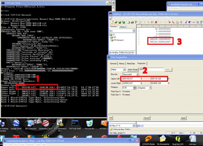
การดู boundary ของข้อมูลภาพดาวเทียมโดยใช้ software FWtools ใช้คำสั่ง
gdalinfo filename.tif จะเห็นได้ว่า boundary ของภาพ Upper Left คือ 265148.637 E 560130.326 N (1)
ส่วน การดูด้วย software PCI ให้เปิดภาพขึ้นมาเลือก tab> file Click ขวา ที่ภาพเลือก Properties ดูที่ Projection จะเห็นได้ว่าค่า Upper left มีค่าเท่ากัน คือ 265148.637 E 560130.326 N (2)
แต่หากดูที่ file นามสกุล tfw file ซึ่งติดมากับ TIff file คือ ESRI World file format การเปิดโดยใช้ text editor เช่น Notepad หรือ Editplus เปิดจะเห็นได้ว่ามีค่าอยู่ 6 ค่า คือ (3)
1. ค่า Pixel size แกน x
2. ค่า การหมุนของภาพไปจากแกน y
3. ค่า การหมุนของภาพไปจากแกน x
4. ค่า Pixel size แกน y
5. ค่า Easting coordinate ของจุดกึ่งกลาง pixel ของภาพซ้ายบน
6. ค่า Northing coordinate ของจุดกึ่งกลาง pixel ของภาพซ้ายบน
จะเห็นได้ว่า ค่าที่อ่านได้จาก tfw file ค่า 5 และ 6 จะไม่ใช่ค่าพิกัด Upper left ของภาพจริงๆ แต่จะเป็นค่าพิกัดจุดกึ่งกลางของ pixel ของภาพซ้ายบน แตกต่างจากการอ่านของ gdalinfo และ PCI ซึ่งจะ shift อยู่ ครึ่ง pixel ดังนั้นโปรดระวังในการนำไปใช้งานด้วย
ที่มา : https://geo2ass.wordpress.com